free bootstrap themes

Automate Complex Missions

Advanced mission planning, assessment, simulation & optimization tool for safely automating complex autonomous operations in heterogeneous UAS

AGCS fuses multi-modal situational awareness information to synthesize reliable and reproducible application-specific missions while mitigating the operational risks 

AGCS generates optimal 3D mission utilizing redundant situational awareness information including

Energy-aware

Minimum Snap Trajectories

Terrain-aware 

Navigation Quality DEM

Environment-aware

Terrain, Weather & Airspace

Multi-Vehicle Mission

Collison free multi-vehicle paths


    Pre-Flight 3D Mission Analysis and Simulation
       Airframe and Autopilot Agnostic
    Application Specific Planning
    Compatible with Desktop (Windows, Linux, MacOS) and Mobile (iOS and Android)

Industries

Industry focused and application specific mission planning capabilities
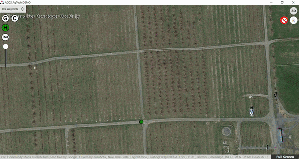
Agriculture

Mobirise

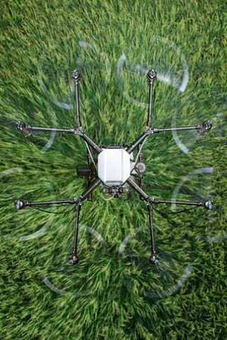
Automate complex flight routines at emergence, crop care, and other phases of the crop cycle to increase the yield by reducing labor overhead.

Urban

Mobirise

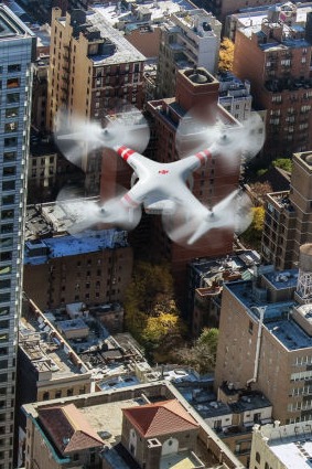
Confidently fly in the dense urban environment to enable last-mile delivery, city planning, public safety, security, emergency response.

Inspection

Mobirise

Protect the assets by periodic close-up inspection irrespective of its location and vertical or horizontal orientation.

BVLOS

Mobirise

Enable the holy grail of unmanned aircraft system with safe and reliable integration in the national airspace.  

AGCS Products

Mobirise

AGCS AgTech [North America]

Automate linear and nonlinear flight path patterns at desired altitude above the crops.  
AGCS AgTech generates optimal terrain aware 3D flight profile for efficient application of drones at various phases of crop cycle. 

Mobirise

AGCS Urban [North America] 

Accurate 2D and 3D Building footprint eases the mission planning in complex urban terrain. Beyond Visual Line of Sight analysis tools aids in decision making for safe and reliable BVLOS missions.  

Mobirise

AGCS Inspection

Optimal helical or spiraling or linear trajectories for inspecting vertical assets. Terrain-aware vertical profiling for facade scanning and exploration graph-based area coverage for inspection large structure scanning application. 

AGCS Microservices (API) 

Latest airborne lidar based high precision terrain data for terrain aware low altitude path planning

Returns the most recent and accurate altitude in AMSL for a given Above Ground Level elevation

Returns minimal energy, terrain-aware flight path with the optimal number of waypoints

Choose from the large selection pre-made blocks - full-screen intro, bootstrap carousel, slider, responsive image gallery with, parallax scrolling, sticky header and more.

No special actions required, all sites you make with Mobirise are mobile-friendly. You don't have to create a special mobile version of your site, it will adapt automagically.

Cut down the development time with drag-and-drop website builder. Drop the blocks into the page, edit content inline and publish - no technical skills required.

Choose from the large selection pre-made blocks - full-screen intro, bootstrap carousel, slider, responsive image gallery with, parallax scrolling, sticky header and more.

207

Missions Planned

395

Flight Hours

About the Developers

Akrobotix is a long term research and product development firm working on autonomous systems & robotics for space, air, land and sea. 


ENDORSED BY

Contact our Team

Our team is happy to answer your technical, product and pricing questions. Please reach out to us with your questions.

© Copyright 2020 Akrobtotix - All Rights Reserved